Living with Faults: The 1872 Lone Pine Earthquake
by Mark McLaughlin
2006
In the Far West, terra firma is an illusion. Alaska experiences the most earthquakes in the country, but California and Nevada rank second and third respectively and together account for about eighty percent of all quakes in the 48 contiguous states.
The magnificent Sierra Nevada is roughly 400 miles long and 45 miles wide, sculpted by glacial ice into steep, deep canyons and elevated peaks exceeding 14,000 feet high. To the casual hiker, climber or skier, the range may seem stable, but it is really in a constant state of uplift that helps offset the weathering process that would otherwise slowly wear the mountains down. Mountains rise along faults and earthquakes result from this building process. Lake Tahoe lies on the western rim of the Basin and Range province, one of the most seismically active regions in the United States.
The Tahoe Basin
The Tahoe basin formed over the course of several million years when a fault on the eastern margin created the Carson Range and a massive upthrust to the west forced the Sierra Nevada up out of a shallow sea. The landmass between these two ranges collapsed and over time filled with water. The Sierra is actually enormous blocks of granite tilted toward the Pacific Ocean, which produce a 35-mile gradual slope on the west, and a steep, 10-mile descent on the east. The westward tilt of the large fault blocks in the Sierra uplift generated towering walls of granite along its eastern edge, which today represent the highest peaks in the Tahoe Basin, such as Freel Peak (10,881’), Pyramid Peak (9,983’ in Desolation Wilderness), and Mt. Tallac (9,735’).
Scientists studying the bottom of Lake Tahoe have found evidence of huge landslides they think were triggered by ancient earthquakes of magnitude 7.0 or larger. Chunks of rock and dirt the size of city blocks may have loosened from surrounding mountains and smashed into the lake during powerful temblors thousands of years ago. Magnitude 3 and 4 earthquakes are commonly felt, but rarely cause damage. Minor to moderate damage can accompany a magnitude 5 or 6 event, and major damage commonly occurs from earthquakes of magnitude 7 and greater.
Geologists have also warned that several faults that lie directly beneath Lake Tahoe are thought capable of generating a 7.1-magnitude quake and enough movement to produce tsunami waves exceeding 30 feet high. But don’t panic and sell your lakefront home — scientists estimate the risk of a magnitude 7 quake under Lake Tahoe in the next 50 years to be between 3% and 4%, far less than the perennial dangers of forest fires and floods in the region. Experts do suggest, however, that if you are near the lake’s shoreline and feel a severe tremor that last for more than 10 seconds, “first duck and cover and then sprint 30 feet in elevation.”
A Mountain Range Grows
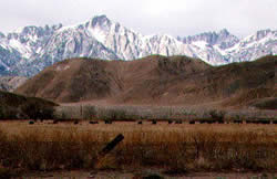
Few people ever see a mountain range grow, but on March 26, 1872, the 300 residents of Lone Pine, California, did. The small hamlet is located on the Sierra east slope near the Owens Valley, about 350 miles south of Reno. This extraordinary seismic event occurred on a clear calm night under a bright full moon. (The belief in “earthquake weather” has been around for a long time, despite common knowledge that shakes occur in any season and at all hours, day or night.) At 2:30 a.m. sleeping residents in Lone Pine were awakened by a sound like rumbling thunder accompanied by the crash of falling dishes, mirrors and glassware. The heaving ground broke plaster from ceilings and tossed water pitchers six feet into the air.
Citizens grabbed what clothes they could and ran from their collapsing homes in stark terror. Timber is very scarce in this region and all the dwellings were built of adobe brick. The brittle adobe construction offered no safety in the severe quake and the destruction in Lone Pine was nearly total. Out of the 62 buildings lining Main Street, 52 crashed to the ground in piles of rubble. Falling bricks and debris killed twenty-seven people. Four miles south of Lone Pine a small lake disappeared and the Owens River decreased in volume. The cloud of dust that rose over the disaster could be seen from 20 miles away. Witnesses reported that “every few minutes heavy shocks of a few seconds duration occurred” and from 2:30 a.m. until 6:30 a.m. there were not less than fifty distinct shocks and “the earth seemed to vibrate all the time.” The first tremor cracked and threw down many walls and buildings, but it was the succeeding aftershocks that leveled the town.
Big Pine Tears Apart
 At Big Pine, 43 miles to the north, the tectonic violence injured many and tore the land apart. A large fissure opened from 50 to 200 feet wide and 20 feet deep, running close along the base of the Sierra Nevada. Along several sections of the road the earth was thrown up five to ten feet, and in many places water was forced out of the barren ground. Springs failed that were never known to be dry before. Several people saw flashes of fire from the mountainsides at points between Bishop’s Creek and Independence. (“Quake lights” are believed to be masses of charged plasma, a high-temperature ionized gas composed of electrons and positive ions, which is theorized to form when earthquakes generate electrical charges that escape through rock layers and into the air.) Rockslides blocked the road with boulders as big as a two-story house. When the stagecoach finally arrived the exhausted driver gasped, “there was not a brick or adobe or chimney left standing between Bishop’s Creek and Independence.”
The great earthquake, estimated at magnitude 8.3 on the Richter scale, was felt from Winnemucca, Nevada, to Oakland, Calif. and all points in between. The jolt was severe enough to stop clocks in Truckee, Blue Canyon and all along the Sierra west slope. In Sacramento where the shaking lasted for a minute and a half, buildings rocked alarmingly and panicked residents poured into the streets in fear. At the Sacramento County Jail, prisoners begged and prayed with tears in their eyes to the jailer in charge to let them out. Their pleas were ignored.
The Party Was Rockin'
The Sacramento Union newspaper reported what happened at a late night party in Turner Hall when the first shock waves reached the valley floor: “Suddenly, while dancing, the ladies looked in an astonished manner at the gentlemen, and the gentlemen at the ladies, each apparently having the suspicion that the other had been indulging too frequently in exhilarating beverages.” The next shock wave ruined the party; “The dance suddenly stopped; many of the ladies fainted, while the occupants in the ballroom, male and female, clung to one another in terror, not knowing what to do.”
Hard rock miners working the night shift far below in the dark shafts beneath Virginia City claimed that the “sensations in the bowels of the Earth were very disagreeable” and they would “infinitely prefer to being on the surface during earthquakes” — a typical Comstock understatement.
The dramatic 1872 Lone Pine earthquake illustrates powerful geologic forces that can literally move mountains. Vertical displacement was measured at nearly 17 feet. It left no doubt in the minds of California and Nevada residents that their shared mountain range could still grow by leaps and bounds.
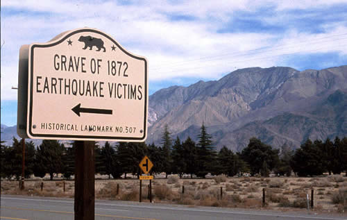
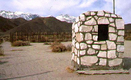
The monument in the foreground is dedicated to victims of the 1872 Lone Pine Earthquake. Behind the monument is a mass grave where the victims were buried. Sierra Nevada in background.
Photos not credited were taken by Mark McLaughlin