1872 Von Schmidt Survey
Sometimes objects are not what they appear.
 Case in point.
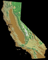
Take a look at your California state map. The eastern boundary of California bordering Nevada is a straight line from Oregon to the middle of Lake Tahoe and then another straight line from Lake Tahoe to Arizona.
Right?
Well, not always. In the 1860s and 1870s, disputes raged between the new state of Nevada and California as to the exact location of the boundary. Despite legislation that defined where the boundary must be, the two states bickered as to where it should be. California had its idea and Nevada had theirs. Nevada felt the boundary should be the crest of the Sierra, while California thought it should be further east. For instance, Susanville in the northeast was claimed by both California and Nevada. Violence actually ensued over the issue. There was bloodshed.
Survey after survey was taken to firmly establish the line. The lines never agreed and they were seldom straight. Some survey lines varied from today’s boundary by as much as three miles. The surveys were mostly performed using 19th century techniques usually referred to as “dead reckoning.” For example, signal fires might be set on one mountain peak, while another blaze, supposedly along the same line, would be set on a nearby high point. Connect the fiery dots and you have your boundary. Efficient, but not a very accurate measurement. And definitely not a straight line.
Enter A.W. Von Schmidt
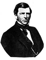 In 1872, an effort was made to resolve the differences and finally mark the actual boundary between the two states. In that year, a San Francisco civil engineer named Allexey W. Von Schmidt was retained to conduct one ultimate, definitive survey to solve the problem. Von Schmidt was a well-known figure who had a prosperous dredging business and done some preparatory work for the construction of the San Francisco Cable Car system. Von Schmidt was provided with a $40,750.32 government contract for the boundary survey. Von Schmidt also arranged to erect cast iron and stone markers along the line, hopefully one mile apart. The markers were five foot tall obelisks engraved with the date of the survey and other useful information. Throughout 1872, Von Schmidt and his surveyors marked the northern boundary from Oregon, and, in 1873, ran the line southeast from Lake Tahoe.
Upon reaching Arizona and the Colorado River, Allexey von Schmidt found that his new boundary line and marker was off by several miles. This was not an unusual occurrence for 19th century surveys and the practice of retracing and correcting the line was standard operating procedure. However, Von Schmidt had spent all of the contract funds. He resolved to start his corrections and petition the government for more money. 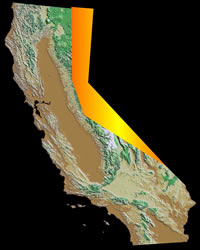 He had completed only about a third of his revisions on the line north to Lake Tahoe, when von Schmidt learned that his request for more funding was denied. He quit at that point and announced that the survey was completed. The end result was a “straight line boundary” that had a pronounced kink in the middle. No one corrected the new boundary and its markers for twenty years.
When, from 1893 to 1899, the United States Coast and Geodetic Survey resurveyed the area, Von Schmidt's kink was found. It was also discovered that quite a few of the cast iron and stone markers were in the wrong spots as well. The state boundary was corrected … again … and serves as the present borderline.
What about the markers? Do they still exist?
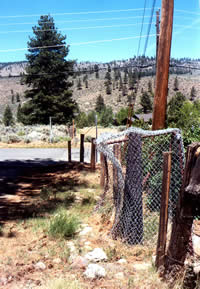
A few markers still survive and proudly stand guard along the boundary. One cast iron marker stands forlornly on a back road in Verdi, Nevada, just off Interstate 80.
One would never know it was a relic of this consequential 1872 geographic event unless you were informed in advance. It stands at the state boundary next to Dog Valley Road, which was the main route over the Sierra Nevada well before Interstate 80, and even before old Highway 40. To reach the marker one must traverse a quiet country lane that leads from metropolitan Verdi, cross two old bridges that are barely one lane wide and keep a sharp eye peeled.
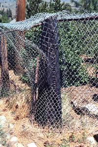
The cast iron marker, clearly showing the 1872 date, stands a few feet from the roadside state boundary signs. It is enclosed by a poorly maintained chain link cage that appears to have been rammed by a pickup truck. Despite being on the National Register of Historic Places, there is no historical marker pointing it out, no plaque describing the reason for it being there. It is just there. The weathered cast iron, now a deep brown, blends into the surrounding landscape, and looks very much like one of the wooden fence posts that stand alongside.
Sometimes objects are not what they appear.
 |
 |
| Credits: Sierra Nevada Virtual Museum staff | |
Other credits: |
|